

![]()
The Walk Ride U.S.A. website has over a thousand interactive maps for locating recreational trails and specific information about the trails. These maps can be zoomed in or out to help you see the overall layout of the trail as well as specific details.
How were these maps created?
The maps were created using Google Maps JavaScript API v3. Each trail is digitized by us from a Google Map in Satellite mode so that the physical trail can be seen.
Data files are created with the hundreds of line segments that make up the complete route for the trails. As you pull up one of our web pages with a map, the basic map information is loaded from Google's servers. The overlays with the colored lines for the trails and parking icons are then loaded from our files.
Why does it take so long for the map to appear?
The maps are being loaded from Google servers, and they load relatively quickly. There is a great deal of information that needs to come along with the map, so it may take some time to load.
There are multiple files that need to load with information for the various trails as well from our servers, so this may take some time, depending on how many trail paths are shown. It also depends on your own internet connection speed.
Can I move or pan the map to a new location?
These maps work like any Google Map. Just click and hold down the mouse button (or swipe on a touchscreen device) to move the map where ever you wish.
What are the buttons in the lower right corner?
![]()
Each interactive map has a set of buttons in the lower right corner.
![]() This button will reset the map to its original state
This button will reset the map to its original state
![]() Clicking on this button will bring up an information box for explanations about what is shown on the map. To close the information box you may click on the "i" button again or on the "X" in the upper right corner of the information box.
Clicking on this button will bring up an information box for explanations about what is shown on the map. To close the information box you may click on the "i" button again or on the "X" in the upper right corner of the information box.
![]() This indicates the current "Zoom Level" for the map. This number will change as you zoom in and out with your mouse or using the sliding Zoom tool, but clicking on the number does not change the Zoom Level. Google maps have set zoom levels that show different levels of detail. This can be useful if comparing two different maps and for other purposes.
This indicates the current "Zoom Level" for the map. This number will change as you zoom in and out with your mouse or using the sliding Zoom tool, but clicking on the number does not change the Zoom Level. Google maps have set zoom levels that show different levels of detail. This can be useful if comparing two different maps and for other purposes.
![]() Clicking on this button will turn on Google's "Bike Layer". This will show all of the bike lanes, trails and pathways that Google has mapped for that area. The Google trails are all in the same green color, but may be underneath the colored trail that is placed on the map by Walk Ride U.S.A. We do not always show all of the same trails as Google's Bike layer.
Clicking on this button will turn on Google's "Bike Layer". This will show all of the bike lanes, trails and pathways that Google has mapped for that area. The Google trails are all in the same green color, but may be underneath the colored trail that is placed on the map by Walk Ride U.S.A. We do not always show all of the same trails as Google's Bike layer.
How to I zoom in or out?

To zoom in or out on one of our map you can use the plus or minus signs provided by Google, or you can use your scroll wheel on a mouse. If you are viewing the map on a touch screen device you can pinch to zoom in or spread your fingers to move out.
Map View vs. Satellite View
 On every Google Map, there is an option for selecting Map View or Satellite View. Map View displays the street layout, city names, and some other features, but not the photographic view with the details. The Satellite View shows the compiled photographs of the area take from space. This view shows all the details, such as buildings, homes, parks, parking lots, etc.
The map is initially in Map View for faster page loading. The colored lines representing the trails are easier to see when the view is in Map View.
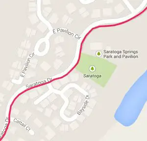
 You can see the difference between Map View and Satellite View in the two images to the left.
Satellite View displays more detail, but the map will load, zoom and pan more slowly.
 To rotate the Satellite View, click on the curved arrow. The view will rotate 90° for each click.
Google will often tilt the view at tighter zoom levels so that the features are more recognizable. To "untilt" the Satellite View, you can click on the button that looks like a tiny grid.
You need to realize that some of the photographs taken from space are several years old and may not reflect the current conditions. This is especially true for trails located in new developments or that have had improvements or have been relocated.
We can only display the routes for the trails as they are shown in the available Satellite View. Be aware that routes and trail conditions may be different than what are displayed on the maps on Walk Ride U.S.A.
Which trail is which?
![]()
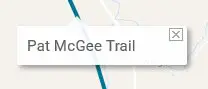
You can double-click on any of the colored trail lines on the map to see the name of that trail.
The trail name will appear in a white box near where your just doubleclicked.
To close the label, click on the little "x" in the upper right corner.
We don't include a legend because some maps have so many trails, that we run out of color possibilities. The color of one trail may be mistaken for another trail, and this could lead to confusion
If you see a label for the trail when zoomed in, this is a Google label for the trail. We do not have our trail labels spelled out in this manner. You can see the Walk Ride U.S.A. label for the trail by doubleclicking on the colored line.
How does Walk Ride U.S.A. determine the name of the trail?
Whenever possible, we label the trails per the names from official sources, such as local government web sites. If no name is given to the trails in the information from these sites, we will label the trail per the street, park, creek or other obvious nearby feature. Often, local communities will have multiple neighborhood trails that do not have individual names. In these cases, we will label them with the name of the community.
It may be that when you zoom in you will see that the name that Google has given the trail differs from the Walk Ride U.S.A. name for the trail. This may be that there are more than one name for the trail or that we have found an official source for the name of the trail and we chose to use that for its label.
Walk Ride U.S.A. has no control over the labels that Google places along the trail. We cannot turn off these labels as it would turn off other necessary labels.
Parking Icons
![]()
For most maps you will see the parking icons only when the map is zoomed in.
Hover your mouse over the icon and a label for that parking lot or trailhead will appear.
You can zoom in closer to see exactly where the parking area is located.
You may need to switch to Satellite View to see details such as access paths or where the entrance is to the parking area.
Some parking areas may also be official trailheads for the trails, others are located in nearby parks. We only added icons for public parking areas within easy access to a nearby recreational trail.
How long is the trail?
We often give an overall distance in miles for the entire route of the trail in the description area. Some of these trails are many miles long and we realize that most people are not going to travel the entire length of the path, even on a bike. To give a total length for the trail could prove difficult or misleading when in some cases the trails double up, spit, or start and stop with gaps or have multiple access points.

There is also a scale provided by Google on the lower right area of the map. You can toggle between km and miles by clicking on the scale. We realize that this is not all that helpful when gauging distances along the trails.
Use our Handy Distance Tool
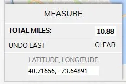
We have provided a handy MEASURE to help you calculate distances on the map. Enable the tool by clicking on the MEASURE button. The MEASURE box will pop up. Here you will see the where the total milage will appear.
Once the MEASURE is enabled, click along your route and you will see the path appear with small red triangles at each click point. The total distance will update in the MEASURE box in the lower left corner.
You can also click on one of the small red triangles along your route to see what the milage is to that point from your starting point.
When you use the MEASURE tool, there is also a box that pops up with the Latitude and Longitude for the last point. This will change with each new point entered (it does not go back to previous points if you use the Undo button). This information may prove useful if you have a GPS program and you wish to plug in the Latitude and Longitude for a particular location.
Make a mistake while clicking?
You can click on the UNDO LAST button to remove one or more of your waypoints. The total distance will reflect this change.
Want to start over?
To clear your digitized path, click on the CLEAR button or click on MEASURE to close the box.
Want to measure a distance somewhere else in the world?
You can use this MEASURE tool for areas that are not covered by our maps. Just pan the map to the area in the country (or the world) and click away.
Larger Maps Available

If you want to see the area in question on a larger map, there is the option to switch to the full page map.
Why isn't the Walk Ride U.S.A. trail in the same place as the Google Trail?
When you zoom in on an area you may notice that the colored line that represents the trail doesn't quite agree with where Google has their line and/or labels. This is because, when we digitize the route of the trail, we have the satellite view turned on. We trace the visual path for the trail, as best as is possible with this technology.
There are many instances where the trail goes through heavily wooded areas, or other obscured areas, and cannot be seen on the aerial image. In these cases, we may fall back on replicating the line that Google has for the trail.
Why don't you show if the trail is paved or unpaved?
Because we are working with satellite imagery, it is not always possible to discern where the trail is paved or has an improved soft surface. Some trails have sections of pavement mixed with unpaved sections. We realize that this information is important for those on road bikes. We do supply links to the official agencies responsible for the trails and you may contact them for specific information.
Most, but not all, of the recreational trials that we have shown are paved. We focus on those trails with our maps. There are however many wonderful recreational trails that have an improved soft surface that is suitable for walking and many types of bikes. If we see that these warrant being included with the others, we will add them to the map.
Why don't you show every trail?
Our focus is to highlight the major public recreational trail systems in each area. These are the trails built by states, counties or local municipalities or other agencies. If we have omitted some trail that you feel should be included, please let us know at This email address is being protected from spambots. You need JavaScript enabled to view it. .
Disclaimer
Walk Ride U.S.A. is not associated with any government or other official agency. This website is built to highlight the recreational trails in many regions of the United States. We do have advertisements to help offset the costs of web hosting and the time spent in creating these pages. We do not have paid subscribers or registered users.
Use this information at your own risk. You are responsible for taking safety precautions and for knowing where you are on the trail and being sure that you are travelling safely.

Tweet